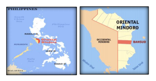
Bansud is a Philippine municipality located in the province Oriental Mindoro in Region IV-B MIMAROPA which is a part of the Luzon group of islands. The municipality of Bansud is seated about 91 kms from the capital City of Calapan and about 153 kms from the Philippine main capital. Manila. The geographic coordinates of Bansud are 12° 49′ 59” N, 121° 22′ 0” E.
Bansud is bounded in the north by the municipality of Gloria, municipality of Bongabong in the south, Tablas Strait in the east and mountains of Occidental Mindoro in the west.
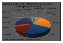
Administratively, the Municipality of Bansud is subdivided into 13 barangays. One forms the center of the municipality whereas the other 12 are in the outlying areas. Some of them are even several kilometers away from the center of the municipality.
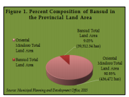
Based on the Cadastral Map issued by the Department of Environment and Natural Resources (DENR), the computed total land area of the municipality of Bansud was Thirty Nine Thousand Five Hundred Twelve and Thirty Four (39,512.34) hectares. This land area is the one being used for planning purposes. It accounts for the 9.05 percent of the total land area of the province or Oriental Mindoro which is Four Hundred Thirty Six Thousand Four Hundred Seventy Two (436,472) hectares as shown in Figure 1. It is one of the medium – sized municipalities in the province in terms of land area. On the other hand, the total land area of the municipality which was approved by the DENR – Land Management Bureau is Thirty Four Thousand Three Hundred Forty Seven (34,347) hectares.
The municipality of Bansud comprises thirteen (13) barangays. Three (3) barangays were classified as urban having a total land area of 2,025.96 hectares or 5.13 percent land share of the total land area of the municipality. The remaining ten (10) barangays were classified as rural having a total land area of 37,486.38 hectares which makes up the 94.87 percent of the total land area of the municipality. Land area distribution and percent land share of each barangay were shown on the following table and on Figure 2.